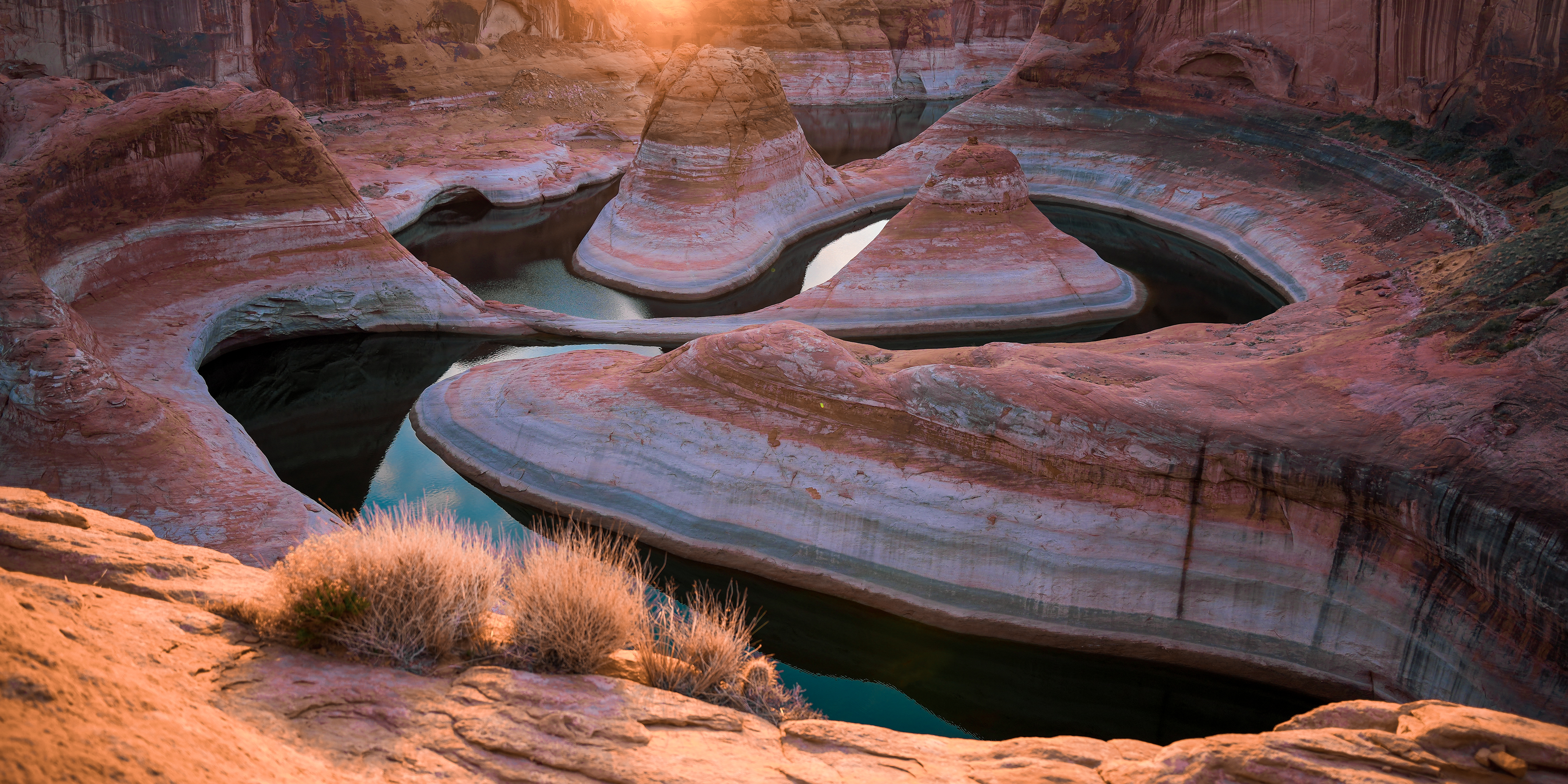
Reflection Canyon — a labyrinth of horseshoe bends cut into Utah slickrock, Glen Canyon National Recreation Area.
Coleridge's sailor had water everywhere and not a drop to drink. Here the problem is not salt, it is slope. There is an arm of Lake Powell directly below you, close enough to photograph. There is exactly one way down to it, and it is several hundred feet of free fall.
- Distance
- About sixteen miles round trip. Eight in, eight back. Go overnight — you want to be there for the light, not walking towards it.
- Trailhead
- An unmarked dirt pull-out on Hole-in-the-Rock Road (BLM 200), roughly 50 miles down from the Highway 12 turn-off southeast of Escalante. Room for about three cars. No sign. Around two hours from town.
- The road
- Fine as far as the trailhead when I drove it, though conditions vary. Beyond it, towards Hole-in-the-Rock itself, it becomes something else entirely — see below.
- Permit
- Free backcountry permit from Glen Canyon NRA for overnight trips. Unlimited, no lottery — walk into the Escalante Visitor Center and pick one up before you drive out.
- Navigation
- An informal trail for much of it, then the last couple of miles are open slickrock with nothing to follow. CalTopo on the phone plus a paper map. Cairns exist but are very easy to lose.
- Water
- None you can rely on. Carry every drop for the whole trip. See below — this is the part that hurts people.
- Shade
- Effectively none the whole way in.
- Tent
- Freestanding. There is nowhere near the good ledge to drive a stake into.
- Best light
- Sunrise, clearly. Sunset is the lesser of the two here.
The lake below you is not water
This is the thing to understand before you commit, and it is the reason I would not send a casual hiker out here.
You will walk eight miles across open slickrock in the desert. At the end of it you will be standing on a rim looking down at an arm of Lake Powell — narrow enough here that it still reads as the drowned river canyon it actually is. Every instinct says you have arrived at water.
You have not. The sandstone rolls over and drops. There is one way down from this overlook and it is hundreds of feet of free fall. The ground that looks as though it might go is precisely the ground you should not test — it would be easy to slide here, and never stop.
There is one apparent exception and it is not one. Scattered across the slickrock are potholes — water pockets, in the Colorado Plateau vocabulary — where the stone has been scoured downward in a spiral to a point.
You know the charity coin funnel that sits by the till in American restaurants: a kid drops a quarter in at the rim and it races around and around, faster and tighter as it goes, until it vanishes down the hole in the middle. That shape, pressed into sandstone. Sometimes there is water sitting in the bottom of one. You should not count on it and you should not plan around it.
Treat them as a hazard in their own right. There are a great many of them, the walls are smooth and lean inward as they narrow, and there is nothing to get a foot or a hand on once you are inside. That is precisely how a person or a dog ends up stuck in one — not by falling any great distance, but by dropping into something deeper than it looked from above, with nothing to climb back out on.
Plan as though there is no water on this route, because functionally there isn't. Every litre for sixteen miles of desert walking, plus the overnight, goes on your back from the car. People get this wrong because the lake is visible, and visible water is very persuasive when you are thirsty. There is also effectively no shade the entire way in.
The road is not the problem people think it is
The trailhead is an unmarked dirt pull-out on Hole-in-the-Rock Road, about fifty miles down from where it leaves Highway 12 southeast of Escalante. Reckon on two hours to cover it. There is no proper sign and no facilities — it is space for about three cars at the side of the road, and that is the entire trailhead.
Getting there was fine. That is worth saying plainly, because the forums will convince you otherwise. Conditions on a dirt road of that length obviously vary with weather and grading, so check locally before you commit — but the drive to the trailhead is not the ordeal it is made out to be.
Pick up the backcountry permit at the Escalante Visitor Center on your way through if you are staying overnight. They are free and unlimited, which is unusual enough in Utah to be worth saying twice: no lottery, no booking window, just walk in.
Do not carry on to Hole-in-the-Rock
This is the part I would tell a friend.
After we got back to the car the following day, my hiking partners wanted to keep driving to Hole-in-the-Rock itself, at the end of the road. That is where things got genuinely bad. We travelled at five miles an hour — the road was that awful — for about an hour.
My friend was driving a four-wheel-drive truck and was willing to punish it in a way I would not have been willing to punish mine. And having done it: it was not worth it. Not for what is at the end, and not for what the drive costs your vehicle.
So separate the two decisions. The trailhead is an easy drive and the hike is the reason you came. The final stretch to the end of the road is a different proposition entirely, and skipping it costs you nothing.
The last couple of miles have nothing to follow
The first stretch is easier than its reputation — there is a discernible informal trail for a good part of the way in. Then it stops. The last couple of miles are open slickrock, and there is nothing underfoot to tell you that you are going the right way.
People have placed stone cairns to mark the general direction. They help, and they are very easy to lose — you look away, you crest a rise, and the next one is not where you expected it. Do not build your navigation around them.
Carry a mobile app and a paper map, and know how to use both. CalTopo is probably the ideal app for this. The terrain looks broadly the same in every direction out there, which is exactly the condition in which people get confidently lost.
Leave the dog at home
My friend brought his, which was a little regrettable. There is almost no shade on the hike in, and it showed: every mile and a half the dog would find the slimmest scrap of shade under some small bush and need to rest.
He was fine, but it set the pace of the whole walk, and it is a lot to ask of an animal across sixteen miles of open rock with no water. Add the spiral pits — which a dog can drop into as easily as a person, and rather more suddenly — and this is simply not a dog hike.
Sleeping at the rim
We went in overnight, which is the right call: you want to be there for the light, not walking towards it.
The practical constraint is the tent. There is not much space for a staked tent near the ledge you want to shoot from, and the ground is rock and shale in every direction. A freestanding tent is very much preferred — bring one you can pitch on bare stone and weight down, not one that needs soft ground and guy lines.
What I got wrong
Two mistakes, both at the moment that mattered.
First, I did not bracket. Shooting the sunrise on a Sony A7 IV, I let the highlights in the sky go — blown out and overexposed, unrecoverable. Bracket here. The dynamic range between lit sky and shadowed canyon at dawn is exactly the situation brackets exist for, and you get one attempt at it.
Second, I wasted time on an ND filter I did not need. I wanted the water far below to go silky-smooth, so I stopped to fit the filter — and the water was already quite still to begin with. The effect was unnecessary and the minutes were not. Look at what the water is actually doing before you decide to solve it.
And for what it is worth: the sunrise was far more interesting than the sunset. If you only get one, get up.
How I would do it again
If I were out here on my own, or with other photographers rather than hiker-friends, I would plan for the long stay: a sunset, a sunrise, then the whole day on the rim, then a second sunset and a second sunrise before walking back to the car.
That means carrying enough water for all of it, and — the part people forget — enough entertainment to pass an entire desert day in one spot with nothing to do. Two shots at each light is the difference between coming home with the photograph and coming home with the one you got.
It is also the difference between hiking companions and photography companions. Hiker-friends will not want to sit on a rim for thirty-six hours. Plan the trip with the people who will.
The last few feet
The composition everyone comes for is not taken from the safe ground. I edged out onto a small ledge with a camera pack and a tripod, grateful for a new pair of shoes with grip. That is the honest description of it — you are working near an edge, carrying awkward weight, on rock that gives you no second attempt.
Decide in advance how far you are willing to go for the frame, and decide it in daylight when you are not tired and the light is not about to do something. The photograph is not worth the other outcome.
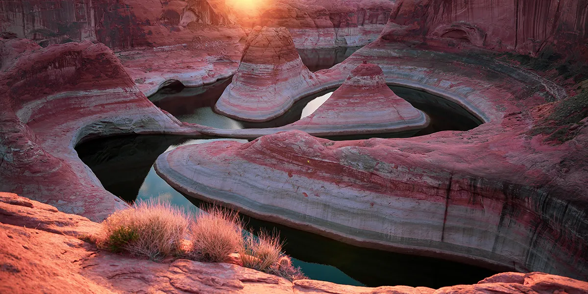
The Labyrinth, Reflection Canyon
Sixteen miles of walking, on fine art paper, metal, or canvas. From $50, free US shipping.
See the print →Road conditions, permit rules and lake levels all change. Check with the Glen Canyon NRA and the Escalante Visitor Center before you drive out. Last checked August 2026.